 AccuWeather reports cold air will be less intense and much less widespread across the nation during the week of Thanksgiving, but there will still be a few travel trouble spots including areas of winter-like conditions and rain-related issues.
Arctic cold will release its grip over much of the nation by the time millions hit the roads and the skies during the busiest week for travel of the year.
However, while the warmest weather will be in the traditional areas of Hawaii, South Florida and Southern California, early-week travelers may encounter some weather-related problems departing their location and a few may find some rain when they arrive.
In a press release by the American Automobile Association (AAA), an estimated 46.3 million people will travel 50 miles or more from home during Thanksgiving with 41.3 million traveling by automobile. The total number of expected travelers is the greatest since 2007, according to AAA, with low fuel prices having a positive impact on travel by vehicle.
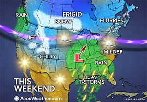
 A storm is forecast to bring rain to most areas east of the Mississippi River Sunday into Monday. The rain could be drenching enough at times to slow travel for a time in Chicago, Detroit, Atlanta and the Interstate-95 cities in the Northeast. Where deep snow remains on the ground, near the Great Lakes, urban flooding problems may occur. Severe thunderstorms and localized flooding may also occur in parts of the South.
According to AccuWeather Chief Meteorologist Elliot Abrams, “Poor visibility in fog may be another element the warmup and rain from the storm brings.”
In the wake of that Sunday to Monday rainstorm, a pocket of cold air will expand from the northern Plains to the Northeast Monday into Tuesday. The air will be cold enough to bring bands of lake-effect snow. Cold air may wrap in quickly enough in parts of Minnesota, Wisconsin and the Upper Peninsula of Michigan to bring a general snowstorm Sunday night into Monday. The storm could affect Minneapolis with heavy snow.
Farther south and east, an area of rain is forecast to linger from the northeastern Gulf Coast to the part of the Atlantic coast Monday into Tuesday.
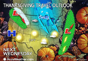
By the big travel day on Wednesday, the weather pattern across much of the nation is projected to be far less stormy, compared to last weekend’s cross-country storm and the Sunday to Monday rainstorm.
 There is a chance this rain backs westward at midweek, if an offshore storm ends up strengthening and tracks close to the coast. In this scenario, rain could back to along part of the Interstate-95 corridor on Wednesday. If the storm remains weak, rain will hover right along the coast before being pushed out to sea. In either scenario, rain will affect part of South Florida for a time.
By Wednesday, only very spotty lake-effect flurries and snow will occur around the lower Great Lakes. Much of the area from the Mississippi Valley to the California coast will be free of rain and snow. Areas from the Midwest to the East coast will be colder than the start of the Thanksgiving week.
Travelers may experience some trouble over the Northwest and northern and central Rockies Tuesday and Wednesday. A batch of snow accompanied with a push of cold air will begin to move southward over the region. This storm and cold push could cause delays along I-15, I-25, I-84 and I-90 in the region from Montana and Wyoming to Idaho, Washington and Oregon. If you will be traveling through this area, make sure you and your vehicle are equipped to handle snow and cold.
Rain may slow travel along I-5 from Bellingham, Washington, to Seattle and Portland, Oregon, during Tuesday and Wednesday.
