
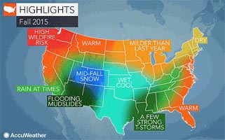
 AccuWeather meteorologists suggest as fall of 2015 unfolds that an already brutal wildfire season will continue across much of California and the Northwest. In contrast, the rain will continue at times in the Southwest even after the monsoon fades in early September.
An expected strong El Niño will lead to beneficial rain for Southern California, but it may be delayed until late fall and winter; meanwhile, flooding and mudslides will threaten the Four Corners region, in addition to some mid-fall snow.
Wet weather is forecast to unfold across the south-central United States after a drier second half of summer, even spreading into the Southeast and mid-Atlantic at times. Farther northeast, a dry autumn is in store for leaf-peepers while the neighboring Midwest will face some chilly conditions.
Mild Air to Stretch Across Northern Plains; Southern Plains to Remain Wet, Cool
Mild air will infiltrate the northern Plains into the fall as warmth that has built up over the summer in the Northwest and western Canada spreads eastward.
“This will start in October then come on strong in November. Temperature departures can range anywhere from 3-6 degrees above normal by November,” Pastelok said.
Come winter, snowfall for the region is predicted to be below normal.
In the southern Plains, increased rainfall, below-normal temperatures and limited sunshine will define autumn. “It may not be extremely cold, but it will be rough to get those sunny days that get those temperatures up during the daylight hours,” Pastelok said.
Warm Weather to Kick off Fall for Mid-Atlantic, Northeast
Fall will get off to a warm start in the Northeast and mid-Atlantic before cooler, more seasonable air settles in during late September.
“There will be some periods where temperatures will come up from time to time. I think there’s going to be that back and forth still going on through mid-fall,” AccuWeather Expert Long-Range Forecaster Paul Pastelok said.
The region will dry out ahead of winter and, overall, the weather will be conducive to leaf-peepers and those planning to attend the region’s many harvest festivals.
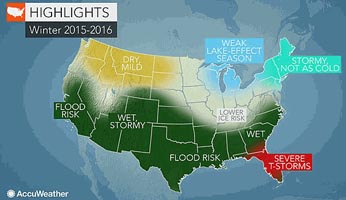 After a bitterly cold winter of 2014-2015, the winter of 2015-2016 will be milder. However, the season will be stormy with near- to above-normal snowfall in the offing for many, which could influence temperatures downward late in the season.
“In the Northeast, we’ve seen a couple of really nasty winters and lots of big storms. And that was without El Niño. El Niño can bring lots of moisture. The question is always, is the cold there when the moisture arrives?”
The moisture may transpire as flooding rains for the mid-Atlantic early, until mid- to late-season when it can be cold enough for snowfall in cities such as Philadelphia and New York City.
Overall, however, the heaviest snow of the season will most likely fall north and west of these areas.
One or Two Tropical Systems in Offing for the Southeast
Despite below-normal numbers predicted for the Atlantic hurricane season, the Southeast could still get one or two impacts into the fall.
“I’d watch the central eastern Gulf of Mexico coastline and also maybe the Carolinas,” Pastelok said. “September is the month. I think after that the threat will weaken fast and go away.”
Regardless of potential tropical impacts, a significant amount of moisture will still make its way into the Southeast through late fall and beyond.
When winter rolls around, severe weather will reignite in Florida, while areas from eastern Texas to Virginia will face rounds of rain and the threat for flooding.
This fall, the Midwest will be milder overall compared to fall of 2014, but it doesn’t mean the crop-growing region will be in the clear of occasional early shots of cold air.
“The Midwest could get an early shot of chill in the second or third week of September that can get cold enough to produce frost,” Pastelok said.
Wild temperature swings are possible at times, with quick snaps of cold followed by a week of warmer weather.
As for late fall and into the early winter season, there is an opportunity for a storm track to come to places like Chicago and Indianapolis, according to AccuWeather long-range forecasters.
Fire Danger to Worsen in California, Northwest
High heat going into the fall and increasingly dry conditions will allow an already brutal wildfire season to worsen across much of California and the Northwest.
“The problem with the Northwest is they’re getting these weak systems that produce spotty storms and they’re kicking off more fires than they’re helping [to extinguish],” Pastelok said.
Into October, the region could also get some late-season 90-degree days.
However, in California, Santa Ana winds will be at fault through September and October. This will bolster the fire threat, in what has already been a deadly and destructive season.
Some rain is possible for the drought-stricken state from October to November, though it will hardly make up for the existing deficit.
The greatest chance for denting or eliminating the long-term drought will be in winter and early spring with the help of a strong El Niño.
Wild Weather to Grip Southwest, Four Corners
After a few years of drought conditions for the Four Corners region, heavy rain can settle in this fall leading to significant flooding and mudslide events through November.
Drought conditions have fueled wildfires over the past few years, resulting in unrecovered burn scar areas.
“When you put a lot of rain on top of that, you’re going to get a lot of mudslides and you’re going to get a lot of flooding a lot easier. That’s the problem they’re going to face this season,” Pastelok said.
By November, temperatures will drop well below normal across the Southwest, leading to a very active, wet and snowy season, typical of an El Niño pattern.